2.5 Depth of tide
2.5.1 Predicting high and low water*
We saw in the last section how to use a tide table.
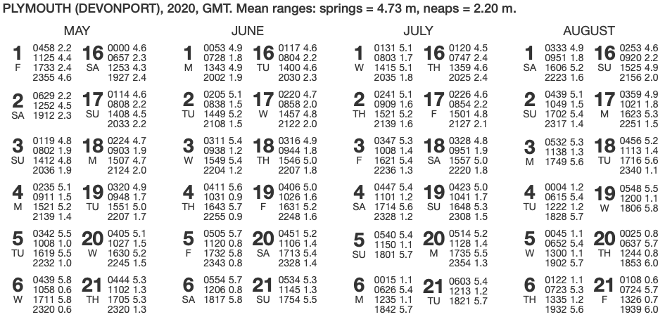
First few rows of a tide table for Plymouth.
Such detailed data is not available everywhere that we would wish to paddle. To overcome this problem, reference books quote tidal constants for other locations. These are either added or subtracted to times of high and low water at standard ports to give local high and low water times. For example, this extract from a paddling guidebook tells us when HW and LW will occur at a location in the Isles of Scilly.
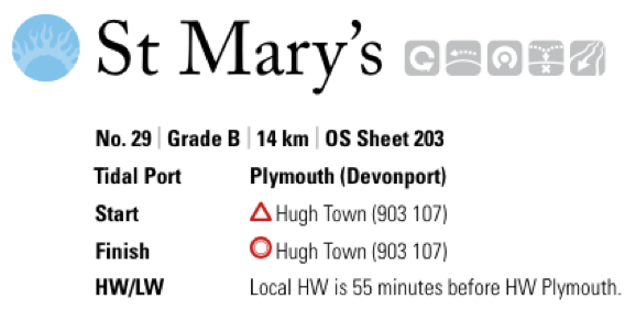
Extract from the excellent Pesda Press (https://www.pesdapress.com) guidebook to South West England. Notice that it tells us that high water at St. Mary’s will occur 55 minutes before high water at Plymouth.
Find times of high and low water at St. Mary’s during the day on June 1st 2020.
Using the tide table, we can find the times of high and low water at Plymouth - ignoring the high water in early morning, and the low water late at night and remembering to add an hour for British Summer Time:
08:28 BST High water Plymouth
14:43 BST Low water Plymouth
We are told that HW and LW occur 55 minutes earlier than they do at Plymouth. Subtracting 55 minutes from the Plymouth times gives:
07:33 BST   HW ST MARYS
13:48 BST LW ST MARYS2.5.3 Estimating the depth of the tide
So, we can find out the times and heights of high and low water. But what if we are interested in the height of tide at a different time in the tidal cycle?
Skippers of yachts and captains of big ships are very interested in accurate predictions of the depth of the tide, and use tidal curves from nautical almanacs to get a precise answer. Sea kayakers rarely need such precision - but it’s helpful to remember that the tide rise (or falls) slowly in the first and last hours after/before high/low water, and rises/falls quickly in the middle hours between high and low water.
The rule of twelfths gives us a little more precision:
The tide rises (or falls):
1 twelfth of it’s range in the first hour after high/low water
2 twelfths in the second hour
3 twelfths in the third hour
3 twelfths in the fourth hour
2 twelfths in the fifth hour
1 twelfths in the sixth (final) hour
To make this a bit more real, let’s consider a slightly contrived example. Imagine a harbor that has 12 steps up the harbor wall:
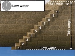
Low water today is at 12:00, and at low water, the water level is at the bottom of the first step. It just so happens that high water today will be at the top of step 12, 3.6 m higher. So, a twelfth of the tidal range is 3.6 m/12 = 0.3m = 30 cm = the height of one step.
Let’s see what happens after each subsequent hour.
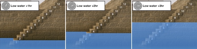
After the first hour, at 13:00, the tide has risen 1/12 of it’s range - one step.
In the second hour (14:00), it rises a further 2 steps (2/12 of the range) to the top of step 3.
In the third hour to 15:00, the tide rises 3 steps (3/12 of the range) more, to the top of step 6.
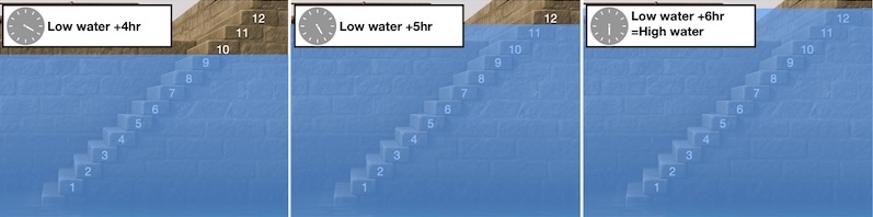
After the fourth hour, at 16:00, the tide rises 3 steps more to the top of step 9
After the fifth hour, at 17:00, the tide rises 2 more steps to the top of step 11
After the sixth hour, at 18:00, it is high water, and the water has risen a further 1 step to reach the top of step 12
Let’s look at a more practical example.
You would like to paddle the drying channel between Saint Agnes and Gugh on the afternoon of September 23rd 2025. At what time will the channel be underwater?
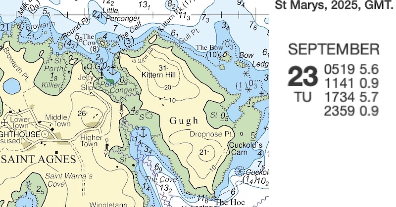
Chart extract of St. Agnes and Gugh, with tide table extract for September 23rd 2025
St. Mary’s harbor is very close to Gugh, so we can use the St. Mary’s times and heights without adjustment. We see that on the afternoon of the 23rd September, the low water height in 0.9 m and the high water height is 5.7 m, so that the tidal range is 5.7-0.9=4.8 m.
As we will be using the rule of twelfths, we will need to calculate 1/12 of 4.8m=0.4m
It is clear that the channel will only cover near the top of the tide, so we use times from high water. We note that the tide table is in GMT and 23rd September is in British Summer Time, so we must add one hour, giving a high water time of 18:34 BST, so:
At 18:34, the height of tide is 5.7 m (from tide table)
At 17:34, the height of tide is 1/12 of the range lower = 5.7-0.4= 5.3 m
At 16:34, the tide is 2/12 lower again = 5.3-2X0.4= 4.5 m
So, we expect the sandbar across the channel to cover just after 16:34, and be well covered by 17:34.
Chart © Crown Copyright and/or database rights. NOT FOR NAVIGATION. Reproduced by permission of the Controller of Her Majesty’s Stationery Office and the UK Hydrographic Office (www.GOV.uk/UKHO)