4.4 Distance, speed and time
It is useful and good practice to estimate the time that should be taken to get to the next waypoint on our route. This enables estimation of how far has been paddled (e.g. ‘we’re half way there’) and acts as a check on the speed of the group. Slow progress could indicate tired paddlers or an unexpected tidal stream in the opposite direction.
4.4.1 The units of the sea*
Distances on the sea are measured in nautical miles. One nautical mile is defined as one minute of latitude. This means that, as well as the chart scale, the latitude scale on the chart can be used measure distance. For example, on the example chart below, the distance from the Old Wreck buoy to Spencers Ledge Buoy is about 0.7 nautical miles.
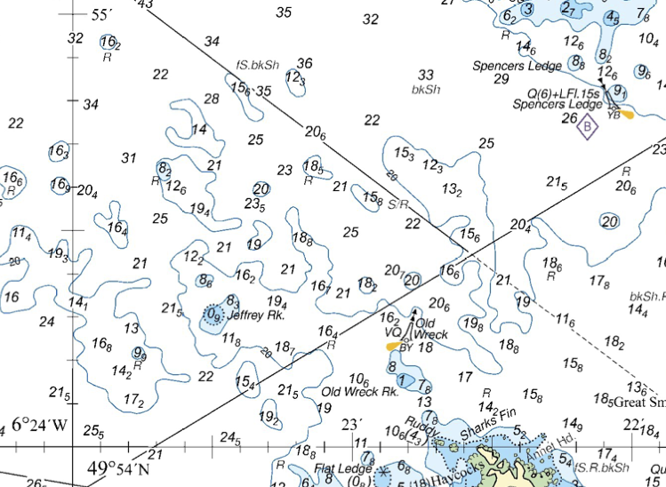
Chart © Crown Copyright and/or database rights. NOT FOR NAVIGATION. Reproduced by permission of the Controller of Her Majesty’s Stationery Office and the UK Hydrographic Office (www.GOV.uk/UKHO)
Never use the longitude scale to measure distance. A glance at a diagram showing lines of longitude shows that they converge at the poles. So a minute of longitude varies from about 1,855 m at the equator to zero at the poles. This makes the longitude scale useless for measuring distance.
How far is it from the Old Wreck Buoy to Jeffrey Rock? I measure the distance on my screen with a ruler as 42 mm - your measurement may differ, by the important thing is that this is about 4 and a half ticks up the latitude (vertical) scale on the map. 10 ticks up this scale is 1 minute of latitude, or 1 nautical mile. So, the distance is 4.5/10 = 0.45 nautical miles.
One nautical mile is approximately two kilometers and is very close to one statute mile. Kilometers are a more natural unit to use on OS maps with 1 km squares, but it helps to think of 2 squares as a nautical mile.
A boat that moves 1 nautical mile in one hour is said to have a speed of 1 knot. This would be rather slow. An inexperienced group of paddlers might expect to move at 2 knots, whilst a small experienced group might cruise at 3 knots. A fast and fit paddler might be able to cruise at 4 knots and sprint at 5 knots for a short period.
4.4.2 Distance, speed and time calculations
If we know how far we’re going and how fast we’re paddling, we can calculate how long it will take using Time=distance/speed.
For example, if we want to paddle 6 kilometers at 2 kilometers per hour, it will take 6/2=3 hours. If we want to paddle 12 nautical miles at 3 knots (i.e. 3 nautical miles per hour), it will take 12/3= 4 hours.
If we know the distance between two points on our route and how long it took to get between them, we can calculate our speed: Speed=distance/time.
For example, if it took us half an hour to paddle 1 nautical mile, our speed is 1/0.5=2 knots.
If speed is known, time taken in minutes can be estimated by multiplying the distance in nautical miles by:
- 30 for 2 knots speed
- 20 for 3 knots speed
- 15 for 4 knots speed
As a guide:
New paddlers in general purpose boats / SUPs / canoes might travel at 2-3 kilometers per hour and want to cover 6-10 kilometers (3-5 miles) of flat water in a day
Regular paddlers in general purpose boats / SUPs / canoes might paddle at 2 knots / 4 kilometers per hour and want to cover 8-15 km (4-8 miles) in a day
A less experienced group of sea kayakers might paddle at around 2 knots / 4 kilometers per hour and want to cover 4-6 miles in a day
A more experienced group might paddle at 3 knots and cover 10-12 miles (20 if they’re fit and keen)
How long will it take to paddle from Portloo to Old Town at 2 knots?
The distance is a little tricky to measure around the wiggly coastline. It is around 6 grid squares = 6 km. 6 km is approximately 3 nautical miles.
Time taken = distance / speed = 3 / 2 = 1.5 hours = 90 minutes
Or, using the numbers given above, time taken = 3 miles X 30 = 90 minutes
4.4.3 Dead reckoning*
If we know how fast we’re paddling, and how long we’ve been paddling since we passed a particular point, we can calculate how far from that point we are. If we also know what direction we’re paddling in (e.g. by following the coast, or by paddling on a bearing), then we can estimate where we are. This process is known as ‘dead reckoning’. It should be done with caution, as it ignores the effect of wind and taking tide into account can be tricky.