3.6 Swell and surf forecasts
Swell forecasts are available from many of the places that kayakers use for weather data - e.g. Windy and Windfinder.
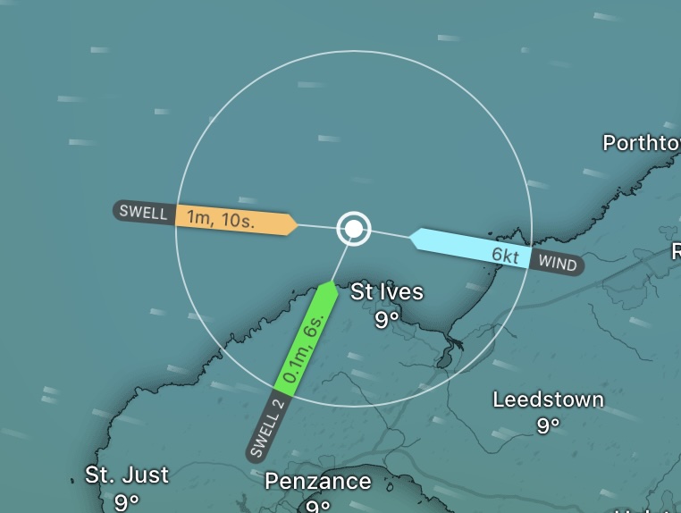
Swell forecast from Windy. I find this graphical view more useful than the tabulated data. Primary swell and a small secondary swell are shown, as well as the wind.
In addition, specialist surf forecasts are available that provide similar data on swell, but also forecast what surf this might generate on specific beaches. Surfline is currently one of the best surf forecast sites.
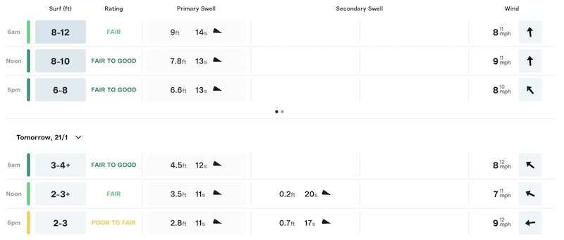
Forecast from Surfline for a specific beach. In addition to swell and wind data, the site forecasts surf height and gives a quality rating.
Whilst most of the terms in these forecasts seem self-explanatory, it’s worth digging into them in a little more detail:
Wave/Swell height - Gives an indication of how it might feel paddling in the swell and (together with period), a idea of the power of the wave when it hits the coast. Waves of 1 meter will feel serious to an inexperienced group - this is about the height when group members will sometimes disappear in the troughs. Typically given as the ‘significant wave height’ - the average height of the largest third of the waves. Whilst this measure gives a good idea of how big the waves feel, around 15% of waves will equal or exceed this height and it’s possible to encounter occasional waves of twice the significant wave height.
Wave/Swell period - Rember that period is the time between sucessive wave creasts. As we’ve discussed, long period swell (e.g. 10 seconds or greater) is easier to paddle in than short period (wind driven) chop. However, long period swell implies a bigger wave for a given height, so the effect of the wave breaking will be more powerful. A weaker ground swell will typically have a period of 7 seconds or more. Swell of 10 seconds or more will form substantial surf. 15 second swell is long - the waves are very long, will break heavily on rocks and may form powerful surf.
Wave direction - suggests where we can find shelter. Waves will tend to diffract around headlands, so shelter may be imperfect depending on the shape of the coastline.
Surf height - the height of surf can be given as the ‘face height’ - the height of the front face of the wave from top to bottom - or the traditional/Hawaiian method which is about half this. Obviously, it’s good to check which scale is being used! Surfline defaults to face height for users in most, but not all, of the world.
Wind speed and direction - is often given on surf forecasts, as it has a marked effect on the surf. Surfers often look for offshore winds, as these tend to ‘hold up’ the wave faces, producing clean and tall surf (this description isn’t technically correct - it’s more the absence of small wind-driven waves causing the wave peaks to break early). Kayakers may find such waves rather powerful, and there are obvious dangers to be managed with offshore winds. Onshore winds will create messier surf, but this can often create a safe learning environment for paddlers… and there will likley be less surfers in the water to avoid too!
As with any forecast, a surf forecast won’t be accurate all the time! Variations from place to place and beach to beach can have a marked effect on the surf, as can local weather conditions.